We are the developer of PeARL® Flash, a multi-user, enterprise-level image processing capability for 3D model generation from imagery data. Post-mission, PeARL® Flash processes airborne frame imagery, Wide Area Motion Imagery (WAMI), and Full Motion Video (FMV) data into 3D models. PeARL® Flash is currently used operationally within many USSOCOM and Army subordinate commands.
In 2020, we funded an Internal Research and Development (IRAD) project to move the PeARL® Flash processing algorithms closer to the sensor. A prototype capability was developed to automatically capture the FMV stream on an aircraft or in an Unmanned Aerial System (UAS) ground control station (GCS) and rapidly process the FMV into 3D models once enough data were captured. This prototype was flown on a manned King Air 350 with a L3Harris-Wescam MX-15 and within a Precision UAV GCS with a Trillium FMV sensor at the end of 2020.
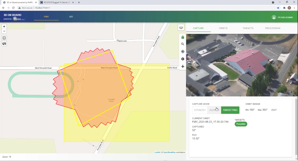
Based on the success of the prototype, we invested in the capability to implement the lessons learned from the flight tests and further commercialize this unique capability, called 3D On Board (3DOB). Updates included designs to adapt to existing FMV usages with no interference or operator intervention. Target areas are added or uploaded to the user interface pre-mission, Figure 1, and no other action is needed during the mission. Should the sensor move away from an area of interest (AOI), 3DOB includes features such as pause/resume, which automatically resumes collection of the target area once focus returns to the AOI.
Additionally, a standardized form factor was chosen. A ruggedized, commercially available 1U server, with dimensions of 22” x 17” x 1.75”, weighing 29 pounds, and requiring 505W of 28VDC or 120VAC power is now available, along with the automation and processing algorithms generates 3D models of scenes within minutes of capture. This fully automated appliance delivers geospatial products to the end-user in standard formats in bandwidth limited environments, removing the need for rear-echelon and CONUS processing. Once enough data of the scene is available, 3DOB automatically processes the FMV stream into 3DOB point clouds, Digital Elevation Models, and textured mesh models.
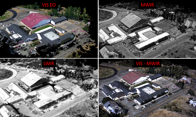
As long as the metadata embedded in the FMV stream is valid, 3DOB is able to process the data, regardless of FMV manufacturer or wavelength. 3DOB has been tested and validated with FMV collections with wavelengths in the visible, mid-wave IR (MWIR), long-wave IR (LWIR), and visible-MWIR multispectral imaging (MSI), Figure 2.
All outputs are in open, industry standard formats, directly ingestible by exploitation algorithms, mission planning and GEOINT analysis tools. This includes American Society for Photogrammetry and Remote Sensing (ASPRS) published .LAS point clouds, 32-bit GeoTIFF Digital Elevation Models, Wavefront (.obj) textured mesh models, and Keyhole Markup Language (.kml) models for Google Earth.
3DOB has been successfully test flown on manned aircraft and UAS’ in 2021. It was formally unveiled the 2021 GEOINT Symposium in St Louis MO and received great attention and revues throughout the conference. 3DOB is the only capability of its kind and is currently available to your customers as a supported Parsons product.