
Preparing for the near-peer competition demands that intelligence operations be conducted in highly contested spaces. Increasing the mission capabilities of unmanned platforms will empower decision-makers with critical information and allow commanders to maintain and enhance their operational advantage while reducing the risk to mission personnel.
QRC, a Parsons company, has been the industry leader in cellular network survey and network characterization with the Integrated Collection System (ICS) product line since 2000. The ICS has been on manned ISR platforms since its inception, but it was clear in the late 2000s that the growth of unmanned platforms made integration an imperative. The ICS has been a payload on unmanned platforms since 2009, flying countless survey missions. These platforms include Unmanned Aerial Vehicles (UAVs), Unmanned Surface Vehicles (USVs), and Unmanned Underwater Vehicles (UUVs).
The ICS was designed to provide users of any experience level a one-button device that provides detailed insight into the network infrastructure, coverage areas by protocol and provider, and the full picture of the RF environment used by mobile communication devices. This ease of use is just one factor that contributes to the value of ICS on an unmanned platform. Combine the low SWaP form factor with the autonomous operation, and you have a payload that completes the mission with no user interaction.
At the heart of the ICS is the autonomous DCode Pro Software which puts understanding of the cellular environment at the users’ fingertips. This software provides a platform to collect, display, and export the collected cellular network parameters. Highlighted features include Geofencing that allows the operators to create pre-defined geographic boundaries where the ICS will collect data; Spectrum Viewer that presents an RF spectral display and identifies various cellular modulation types and signals; and Passive Base Station Location (PBL) that provides the geographic positions of cellular sectors from the ground or airborne surveys.
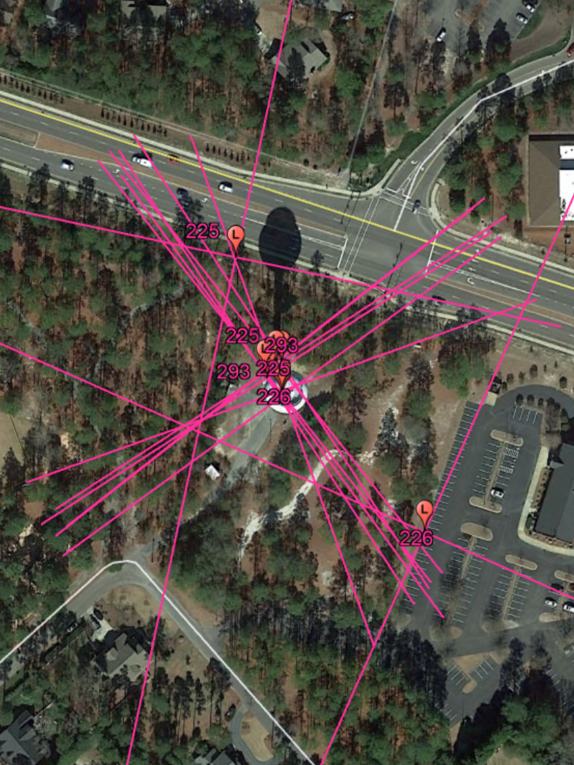
PBL provides incredibly accurate sector location data, which equates to the location of the towers. This replaces a time-consuming task that would take an experienced operator hours to complete. Using PBL in conjunction with unmanned vehicles provides clarity of the RF environment. On ground and maritime missions, PBL Ground can provide tower location within 10s of meters. For airborne missions, PBL Air can be used to estimate the tower location with degrees of accuracy based on the altitude and flight patterns. Flights at 8,500 feet have produced results in which 90% of the towers were located within 200 meters of the actual location. When the airborne survey is combined with PBL Air, the process of mapping cellular infrastructure is literally reduced to hours as opposed to days or even weeks.
Integrating ICS and DCode Pro software into unmanned platforms provides an advantage when competing for information in contested space. The autonomous network characterization capabilities and ability to physically map the locations and then tie them to onboard imagery provide an unparalleled leap in capability. Airborne usage of these platforms on unmanned vehicles not only reduces costs but reduces risks to crew and mission. This capability is what decision-makers and operational commanders need to feed those critical information needs.